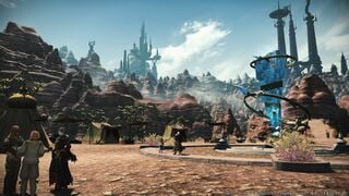
The Peaks
The Peaks

Map of The Peaks
- Type
- Zone
- Zone
- Gyr Abania
(Hydaelyn) - Req. quest(s)
- A Familiar Face Forgotten
The First of Many - Connects to
- Rhalgr's Reach (NW)
The Fringes (W)
The Lochs (E) - Aetherytes
- Ala Gannha (X:23.8, Y:6.5)
Ala Ghiri (X:15.8, Y:36.6)
Situated midway along the eastern arm of Abalathia's Spine, this region is characterized by a succession of steep, stony pinnacles which grow in height and density the further south one travels. When overland trade was still profitable, the area was a hub for caravans bound for the Near East.
— In-game description
The Peaks is a zone in Gyr Abania.
Locations
| Area | Points of Interest |
|---|---|
| The Last Forest | |
| Ala Gannha |
|
| Rustrock | |
| Wightrock | |
| Ala Ghiri |
|
| Mount Yorn |
Activities
Shops & Services
| Merchant Name | Title | Location |
|---|---|---|
| (X:24.5, Y:5.7) | ||
| (X:16.5, Y:36.5) | ||
| (X:19.6, Y:11) | ||
| (X:27, Y:36.7) | ||
| (X:27.7, Y:29) |
Field:
| Coordinates | Description | Number |
|---|---|---|
| (X:24.4, Y:30.6, Z:2.5) | Edge of a small cliff | 4 |
| (X:11.7, Y:26.4, Z:2.5) | Edge of a cliff | 3 |
| (X:16.0, Y:15.8, Z:1.1) | Find the stairs at (X:15.8, Y:14.2) go 2/3 of the way up and go left. | 2 |
| (X:25.5, Y:6.4, Z:0.8) | Starting at Ala Gannha go NW up two inclines, follow this path straight to the coordinates. | 1 |

Quests:
| Quest | Level | Coordinates | Additional Information |
|---|---|---|---|
| Saint Sayer | 61 | (X:24.3, Y:6.8, Z:0.7) | Unlocks after completing Stormblood MSQ The Fires Fade |
| A Hunger for Trade | 68 | (X:27.7, Y:28.7, Z:2.7) | Unlocks after completing Stormblood MSQ Where Courage Endures |
| Out of Sight | 68 | (X:14.9, Y:36.6, Z:2.1) | Unlocks after completing Stormblood MSQ The Path Forward |
| Closing Up Shop | 69 | (X:27.1, Y:36.5, Z:2.7) | Unlocks after completing Stormblood MSQ Raubahn's Invitation |
| Liberty or Death | 69 | (X:26.7, Y:36.2, Z:2.7) | Stormblood MSQ |
Enemies
Normal
- Bloodglider
- Crag Claw
- Earth Sprite
- Fluturini
- Gyr Abanian Hornbill
- Highland Eruca
- Jhammel
- Kongamato
- Marble Urolith
- Muud Suud
- Pantera
- Qiqirn Meatcutter
- Ruud Suud
- Scarab Beetle
- True Griffin
B Rank
A Rank
S Rank
Vistas
Players can unlock Stormblood sightseeing logs by speaking to Ulger Ironheart in Rhalgr's Reach (X:10.5, Y:13). Players must be a Disciple of War or Disciple of Magic level 60 or higher to obtain credit for these sightseeing logs. Vistas are small blue glowing orbs at which players need to /lookout or use another emote.
| # | Zone | Name | Coordinate | Emote | Comment |
|---|---|---|---|---|---|
| 8 | Hidden Tear | The Peaks | (X:33.3, Y:10.2, Z:2.2) | Lookout | Top of cliff. |
| 9 | Coldhearth | The Peaks | (X:27.0, Y:36.8, Z:2.9) | Lookout | Top of the little tower. |
| 10 | Nyunkrepf's Hope | The Peaks | (X:22.0, Y:32.8, Z:3.5) | Lookout | On Nyunkrepf's Hope. |
| 11 | Ala Gannha | The Peaks | (X:25.1, Y:5.8, Z:1.1) | Lookout | Top of the cliff. |
| 12 | Specula Imperatoris | The Peaks | (X:19.9, Y:23.4, Z:3.2) | Lookout | Edge of the north west tower. (Requires flying.) |
| 13 | The Arms of Meed | The Peaks | (X:8.1, Y:37.5, Z:2.6) | Lookout | Behind structure. |
| 14 | The Ziggurat | The Peaks | (X:18.3, Y:14.3, Z:0.8) | Lookout | On the hill . |
| 15 | Emprise | The Peaks | (X:7.5, Y:7.6, Z:0.1) | Lookout | On a pillar (inside). |
| 49 | Ala Ghiri | The Peaks | (X:14.3, Y:36.6, Z:2.6) | Lookout | On the pillar of the western wall. (Requires flying.) |
| 50 | Specula Imperatoris #2 | The Peaks | (X:20.4, Y:22.9, Z:2.6) | Lookout | On top of a lamp near the north west tower. (Requires flying.) |
Achievements
This zone is associated with the following achievements:
| Name | Points | Task | Reward | Patch |
|---|---|---|---|---|
| Mapping the Realm: The Peaks | 10 | Discover every location within the Peaks. | - | 4.0 |
| Freebird: The Peaks | 5 | Attune with all the aether currents in the Peaks. | - | 4.0 |
Music
| Condition | Theme |
|---|---|
| Day | On High |
| Night | The Stone Remembers |
| Settlements | With Giants Watching |
| Battle | Looping in the Deepest Fringes |
Gallery
-
-
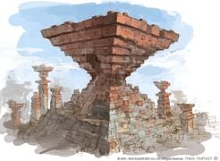 The Ziggurat
 -
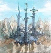 Specula Imperatoris
 -
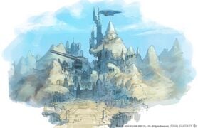 Castrum Abania exterior


Lore
Situated midway along the eastern arm of Abalathia’s Spine, this region is characterized by a succession of steep, stony pinnacles which grow in height and density the further south one travels. When overland trade was still profitable, the area was a hub for caravans bound for the Near East.
The Last Forest
During their escape from the floodwaters of the Sixth Umbral Calamity, those who hailed from the lush lands of Yafaem and the Black Shroud lamented these trees as the last “forest” they were to see. Considering the sparsity of the growth, the term has been deemed somewhat overgenerous.
Emprise
In the past, monks who completed their training at the Temple of the Fist were honored in a ceremony held in this hallowed cloister. Once alive with activity, thronging with monks and pilgrims alike, it was laid to waste at the mad king’s command and is now home to naught but ghosts of the past.
Grymm & Enid
Grymm and Enid were a married couple who wandered the mountains for two dawning of the sun as they sought refuge from the great floods. Upon finding water, they fell to their knees to slake their terrible thirst. But they drank too much, too quickly, and perished by the side of the ponds which now bear their names: the larger Grymm, and the smaller Enid.
Byron’s Bread
A stonecutter from Ala Gannha, Byron turned his hand to farming when the quarry industry went into decline. Though he hoped merely to provide his family’s daily bread, the dry climate and hard ground defeated him at every turn. The late Byron’s dusty patch of land is now tended by his grandchildren, who struggle to produce a worthy crop in honor of his memory.
The Ziggurat
The Sixth Umbral Calamity wreaked havoc upon the realm’s aetherial flow, giving rise to unstable weather patterns. Desiring to correct the disturbance, descendants of the Amdapori and the Mhachi set aside past differences and came together to build the Ziggurat, which served as a weight to still the land’s writhing currents of ether.
The Carmine Kitchen
The Qiqirn bandits who scurry about the Ziggurat use this area for meal preparation, splattering the stones with the lurid lifeblood of their captured prey. Rumors abound that the rat-like beastmen will feast on two-legged game just as readily as fowl.
Ala Gannha
Situated in the Peaks' northern reaches, this village once flourished through its quarry, the beautiful stone sourced and cut here used to build the royal palace of Ala Mhigo. Such prosperous days, however, have become but a memory, and the villagers are faced with the harsh realities of a failing industry.
Rustrock
Taking its name from the land’s predominantly reddish hue, this area was once crowded with stonecutters carving out blocks for building materials. Though quarries were common in the days of the Ala Mhigan monarchy, Rustrock is now overrun with dangerous wildlife and other monstrous denizens.
Mason's Falls
Stone quarried from a location further upriver would be lashed securely to a raft before being pushed over this waterfall. Yet it was so long ago when a raft was last dropped that those who know of the practice—and the reason for the falls' name—are dwindling in number every year.
Heather Falls
A short distance upriver from Mason’s Falls, this cascade is named for the color of its churning waters' froth—a delicate white reminiscent of heather. The plant in question, unlike the hardy native flowers blanketing the falls' surrounds, would struggle to bloom in the region’s barren soil, however.
Hidden Tear
A shrine for honoring the departed, backed by a waterfall whose constant roaring muffles one’s sobs and whose spraying hides one’s tears. Such religious rites were outlawed under imperial rule, and for a long time people could not hold even the simplest services to remember loved ones.
Sleeping Stones
This quarry was once worked by Ala Gannhan stonecutters, the rock said to slumber in silence between each clanging shift. Yet now, with none coming to harvest their bounty, the stones may never again awaken to the kiss of pick or chisel.
The Ephor
Carved in the likeness of Rhalgr in his arbiter incarnation, this statue seemed ever poised to pass divine judgment. The demonic visage and accusatory finger were destroyed, however, when the Garlean army conducted a purge of all religious iconography.
Whitherwander
This winding path was once walked by young men and women seeking to enter the monkhood. It is said that enchanted devices would befuddle those whose concentration wavered, meaning that any unfocused souls would soon lose their way.
Momoroon's Milk
Momoroon, the compassionate greatmother, leads the band of blood-crazed Qiqirn which calls this village home. Tales are told of the “milk” the great- mother feeds to her children—a rice gruel tainted with strange medicines said to nurture a brutal temperament.
Wightrock
This elevated plateau in the southern reaches of the Peaks was originally known as “Whiterock” for its pale and washed-out colors. Traveling merchants who lost many a companion to the area’s vicious wildlife felt that a reference to the dead was the more apt description.
Goodblade
Once the largest caravan waypoint in the region, much of Goodblade was reduced to rubble in the Empire's invasion. Despite its overall ruined state, the chocobo stables and some few other structures yet stand.
Ala Ghiri
Situated along the highroad connecting Ala Mhigo to the rest of Aldenard, Ala Ghiri once served as a hub and vital waypoint for overland trade with the east. After the Garlean invasion left the majority of overland routes destroyed, that trade came to focus upon catering to the needs of the occupation force.
The Scabbard
According to legend, this wind-carved corridor was used by the Destroyer as a sheath for one of his blades. For the local folk, the passage serves as a convenient shortcut when traveling from Coldhearth to Ala Ghiri.
Specula Imperatoris
After claiming Gyr Abania for its own, the Empire erected this monstrous tower in order to maintain watch over the region. A communications spire was later added in preparation for the next phase of the Eorzean invasion, followed by an energy transmitting device for activating the Ultima Weapon.
The Choler
Locals claim that drinking the muddy water which pools at the bottom of a certain canyon in Wightrock is to invite immediate death. Upon conducting, an exhaustive study, however, an Ul’dahn alchemist found the lethality of the harmless liquid to be an exaggeration born of folklore.
The Arms of Meed
Cleanse your mind, hone your flesh, redeem your soul—so teaches the Fist of Rhalgr. The temple was built in accordance with this belief, that those who have committed wrongs might atone for their sins. Seven years of grueling training, here will earn one the Destroyer’s forgiveness no matter the weight of his crime.
Nyunkrepf's Hope
When the Sixth Umbral Calamity befell Eorzea and the realm was transformed into a sea, this great vessel, built by a man hailing far from the north named Nyunkrepf, saved many lives. Having taken aboard countless souls drifting in the floodwaters, it was finally transported by magicks to its current resting place.
Mount Yorn
Upon spying a sharply pointed summit from the deck of his flood-tossed ark, Nyunkrepf mistook this craggy formation as the Isle of Yorn. Though the mountain is quite some distance from the island in the Northern Empty, the appellation nevertheless remains to this day.
Castrum Abania
This imperial citadel rises from the mountains on the eastern edge of the Peaks. After the Battle of Silvertear Skies, Gaius was not eager to repeat the disastrous fate of the grim, and ordered the construction of a cannon capable of repelling even the most gigantic of adversaries.
Radiata
A modest village atop Mount Yorn, this settlement was populated by citizens who had submitted to imperial rule. The village's name is said to be a Garlean word representative of the lines of loyal workers which radiated out towards the nearby Castrum Abania and Specula Imperatoris.
The Ironroad
Laid upon the rocky ground to assist with the smooth conveyance of supplies, this metal-clad path stretches between Castrum Abania and Specula Imperatoris. For the native Gyr Abanians, its uniformly dull and black surface was another unsettling reminder of their continued subjugation.
Coldhearth
Tucked away in a forgotten corner of the Peaks, this sleepy hamlet is known for producing mercenaries, a tradition that was born out of necessity. With its lands yielding precious little bounty, youths took to leaving hearth and home behind to trade their sword arms for coin, most notable among them being Raubahn Aldynn, the Bull of Ala Mhigo. [1]
References
- ↑ Encyclopaedia Eorzea: Volume II, page 77-78
| La Noscea |
| ||||||
|---|---|---|---|---|---|---|---|
| The Black Shroud |
| ||||||
| Thanalan |
| ||||||
| Mor Dhona |
| ||||||
| Coerthas |
| ||||||
| |||||||
| |||||||
| |||||||
| |||||||
| |||||||
| |||||||
| |||||||
| |||||||
| |||||||
| |||||||
| |||||||
| |||||||
| |||||||
| ??? (other regions) | |||||||